


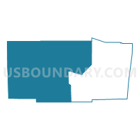
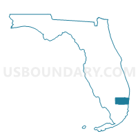
EVERGL-Voting District, Broward County, Florida
About
Outline

Summary
| Unique Area Identifier | 551523 |
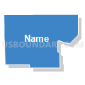
| Name | EVERGL-Voting District |
| County | Broward County |
| State | Florida |
| Area (square miles) | 793.40 |
| Land Area (square miles) | 793.04 |
| Water Area (square miles) | 0.36 |
| % of Land Area | 99.95 |
| % of Water Area | 0.05 |
| Latitude of the Internal Point | 26.24794370 |
| Longtitude of the Internal Point | -80.60531770 |
Maps

Graphs
Select a template below for downloading or customizing gragh for EVERGL-Voting District, Broward County, Florida


Neighbors
Neighoring Voting District (by Name) Neighboring Voting District on the Map
- 153.1-Voting District, Miami-Dade County, FL
- 153.3-Voting District, Miami-Dade County, FL
- 27-Voting District (North of Big Cypress), Hendry County, FL
- 369-Voting District, Miami-Dade County, FL
- 454.7-Voting District, Miami-Dade County, FL
- 502-Voting District, Collier County, FL
- 594-Voting District, Collier County, FL
- 6038-Voting District, Palm Beach County, FL
- 8-Voting District (Big Cypress Ind Res), Hendry County, FL
- E009-Voting District, Broward County, FL
- E010-Voting District, Broward County, FL
- E032-Voting District, Broward County, FL
- E039-Voting District, Broward County, FL
- E041-Voting District, Broward County, FL
- J003-Voting District, Broward County, FL
- J021-Voting District, Broward County, FL
- M001-Voting District, Broward County, FL
- M018-Voting District, Broward County, FL
- M026-Voting District, Broward County, FL
- M029B-Voting District, Broward County, FL
- NP16-Voting District, Palm Beach County, FL
- Q044-Voting District, Broward County, FL
- Q060-Voting District, Broward County, FL
- Q061-Voting District, Broward County, FL
- Q062-Voting District, Broward County, FL
- Q063-Voting District, Broward County, FL
- Q064-Voting District, Broward County, FL
- Q066-Voting District, Broward County, FL
- Q069-Voting District, Broward County, FL
- Q093A-Voting District, Broward County, FL
- W020-Voting District, Broward County, FL
- X012-Voting District, Broward County, FL
- X032-Voting District, Broward County, FL
Top 10 Neighboring County Subdivision (by Population) Neighboring County Subdivision on the Map
- Hialeah CCD, Miami-Dade County, FL (342,086)
- Miramar-Pembroke Pines CCD, Broward County, FL (280,324)
- Plantation CCD, Broward County, FL (261,673)
- Coral Springs-Margate CCD, Broward County, FL (217,025)
- Davie CCD, Broward County, FL (198,764)
- Immokalee CCD, Collier County, FL (50,294)
- Clewiston CCD, Hendry County, FL (19,894)
- Everglades CCD, Collier County, FL (15,084)
- Everglades CCD, Miami-Dade County, FL (6,578)
- Glades CCD, Palm Beach County, FL (517)
Top 10 Neighboring Place (by Population) Neighboring Place on the Map
- Pembroke Pines city, FL (154,750)
- Miramar city, FL (122,041)
- Sunrise city, FL (84,439)
- Weston city, FL (65,333)
- Tamarac city, FL (60,427)
- Southwest Ranches town, FL (7,345)
Top 10 Neighboring Unified School District (by Population) Neighboring Unified School District on the Map
- Dade County School District, FL (2,496,435)
- Broward County School District, FL (1,748,066)
- Palm Beach County School District, FL (1,320,134)
- Collier County School District, FL (321,520)
- Hendry County School District, FL (39,140)
Top 10 Neighboring State Legislative District Lower Chamber (by Population) Neighboring State Legislative District Lower Chamber on the Map
- State House District 112, FL (210,556)
- State House District 101, FL (189,600)
- State House District 97, FL (169,848)
- State House District 78, FL (156,153)
- State House District 77, FL (147,455)
- State House District 96, FL (140,377)
- State House District 98, FL (134,942)
Top 10 Neighboring State Legislative District Upper Chamber (by Population) Neighboring State Legislative District Upper Chamber on the Map
- State Senate District 39, FL (483,183)
- State Senate District 34, FL (481,165)
- State Senate District 40, FL (448,543)
- State Senate District 32, FL (428,898)
Top 10 Neighboring 111th Congressional District (by Population) Neighboring 111th Congressional District on the Map
- Congressional District 25, FL (807,176)
- Congressional District 19, FL (736,419)
- Congressional District 21, FL (693,501)
- Congressional District 20, FL (691,727)
- Congressional District 23, FL (684,107)
Top 10 Neighboring Census Tract (by Population) Neighboring Census Tract on the Map
- Census Tract 112.02, Collier County, FL (18,805)
- Census Tract 1103.24, Broward County, FL (15,742)
- Census Tract 703.17, Broward County, FL (14,665)
- Census Tract 124, Miami-Dade County, FL (9,525)
- Census Tract 79.12, Palm Beach County, FL (9,228)
- Census Tract 203.18, Broward County, FL (8,850)
- Census Tract 204.09, Broward County, FL (7,483)
- Census Tract 111.02, Collier County, FL (7,291)
- Census Tract 703.20, Broward County, FL (7,118)
- Census Tract 601.20, Broward County, FL (6,846)
Top 10 Neighboring 5-Digit ZIP Code Tabulation Area (by Population) Neighboring 5-Digit ZIP Code Tabulation Area on the Map
- 33018, FL (46,117)
- 33029, FL (45,235)
- 33321, FL (44,327)
- 33071, FL (36,964)
- 33351, FL (32,890)
- 33326, FL (31,257)
- 33327, FL (22,658)
- 33440, FL (19,743)
- 33332, FL (11,199)
- 34141, FL (232)